This guide uses Pacific Coast Highway self-drive itinerary as the starting point for the practical advice below. 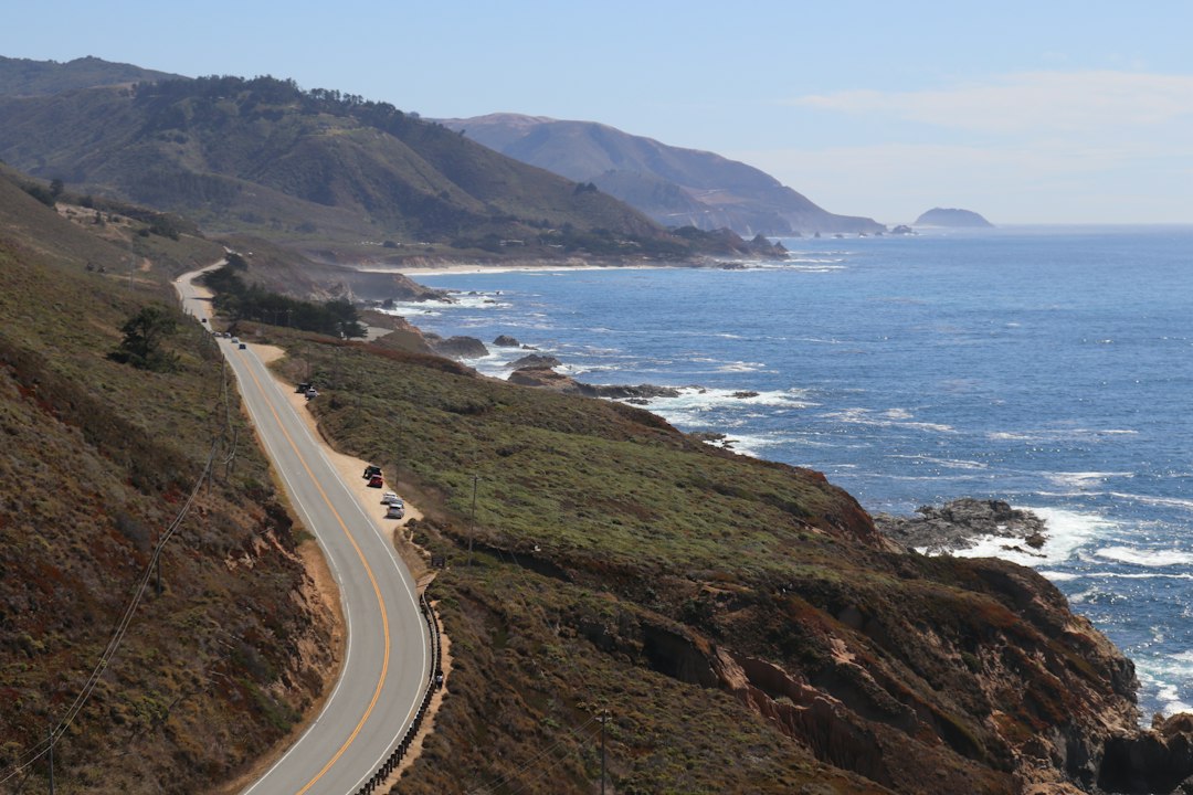
If you’ve been dreaming about an iconic West Coast road trip, the Pacific Coast Highway self-drive itinerary is a timeless favorite. This guide turns that dream into a practical 10–14 day plan with realistic drive times, daily stops, lodging strategies, packing tips, and safety notes so you can savor the coastline without rushing.
Pacific Coast Highway self-drive itinerary: overview
The Pacific Coast Highway (Highway 1) stitches together rugged cliffs, seaside towns, and postcard-perfect viewpoints between San Francisco and San Diego. Many travelers tackle it in 10 days, while others extend to two weeks to linger in Big Sur, Santa Barbara, and San Diego. This overview helps you pick a pace that fits your budget, season, and preferred driving rhythm.
At a glance, a classic route flows like this: San Francisco — Half Moon Bay — Santa Cruz — Monterey/Carmel — Big Sur — Cambria/San Simeon — Pismo Beach — Solvang — Santa Barbara — Malibu — Los Angeles — Orange County (Laguna Beach, Dana Point) — San Diego. You’ll drive fewer kilometers than you’d expect because the road invites frequent stops, short hikes, and long lunches. The keys to a relaxed trip are short driving blocks (1–3 hours), daylight arrivals, and one or two longer stays where you can unpack and breathe.
How long should you plan? Ten days is enough for highlights at a measured pace. Twelve to fourteen days lets you layer in wineries, island day trips, and beach mornings without crowding your schedule. If time is tight, a seven-day “fast track” still delivers the spine of the route with a few smart shortcuts. You’ll find all three versions, plus modular day packs, below.
Before you roll, bookmark an internal planning hub. For more coastal routes and loop ideas, check our self-drive itinerary archive on Traveling RNs, where we collect field-tested routes and logistics checklists.
When to go, which direction, and how weather shapes the drive
Season matters. Winter brings dramatic surf and storms, spring brings wildflowers and fickle fog, summer draws peak crowds, and autumn often serves up the steadiest sunshine and warm seas. Landslides can close sections of Highway 1 any time of year, especially around Big Sur after heavy rain. Always check the Caltrans QuickMap for live closures before you depart and again each morning.
Southbound vs northbound: Southbound (San Francisco to San Diego) positions the ocean on your right, making pull-outs easier and viewpoints more dramatic through the passenger window. Northbound works well too, particularly if flights or rental deals favor San Diego. Whichever direction you choose, align your longer driving blocks with mornings to beat the midday crowds at the most photogenic stops.
Daylight is your friend. These cliffs are gorgeous but demand attention. Aim to arrive at lodgings before sunset unless you’re comfortable with winding roads in the dark. Fog—nicknamed Karl in San Francisco—often rolls in late afternoons and mornings. It’s part of the mood; plan flexible photo windows so you can return if a view is socked in.
How far to drive each day and pacing that keeps the trip fun
Highway 1 is not about distance; it’s about immersion. The most common mistake is stacking too much into one day. A sustainable rhythm for most travelers is 90–150 minutes of actual driving with two or three long stops. That usually means covering 50–120 miles depending on how curvy your segment is (Big Sur miles take longer). As a baseline, assume 35–40 mph average speeds through Big Sur and 45–55 mph elsewhere when traffic is light.
Parking and crowd choreography: Arrive early for famous stops such as Bixby Creek Bridge, Pfeiffer Beach, McWay Falls, and 17-Mile Drive. If lots are full, keep rolling to the next turnout, enjoy a different angle, then circle back. Lunch late—around 2:00–2:30—when restaurants quiet down. For sunset, pick one aim (not three), commit, and enjoy it without sprinting back to your car.
Rest days are investments. Pick two: Monterey/Carmel, Big Sur (if you can secure lodging), Santa Barbara, Los Angeles, or San Diego. A rest day could be a day trip (Channel Islands from Ventura), a harbor cruise (Monterey Bay), or just a beach morning plus laundry and groceries. These pauses make the entire itinerary calmer.
Car rental, one-way logistics, and whether an EV fits this route
One-way rentals: Most major companies allow San Francisco pickup and San Diego drop-off for a fee. If the fee is steep, flip direction or return to your origin by a quick inland route on US-101 or I-5. Book early during summer and holidays; convertibles are fun but plan for sun, wind, and secure trunk space.
Electric vehicles: An EV can work, but only if you pre-map charging around Big Sur where options are limited. North of Monterey and south of San Luis Obispo, charging is easier. If you choose EV, select accommodations with Level 2 chargers and keep a generous buffer. For gas cars, top off in Carmel or Monterey before entering Big Sur; fuel is pricier and sparse between Big Sur and Cambria.
Insurance and roadside plans: Carry a roadside number, examine your spare or repair kit, and download offline maps. Cell signal fades in Big Sur; paper maps or pre-downloaded tiles reduce stress.
Day-by-day route plan (Days 1–3): San Francisco to Monterey/Carmel
Day 1: San Francisco arrival and preview drive. Stretch your legs at Crissy Field with a frame-perfect view of the Golden Gate Bridge. If you have time, detour to Lands End and Sutro Baths for an atmospheric walk above the surf. Stay in the Marina, Presidio, or near Golden Gate Park for easy morning departure. Food ideas: sourdough at Boudin, dim sum in the Richmond, tacos along the Mission’s 24th Street. If you’re collecting rental cars in the city, arrange pickup near Fisherman’s Wharf or SFO to avoid navigating crowded downtown streets.
Day 2: San Francisco to Santa Cruz (via Half Moon Bay). 75–95 miles, 2–3 hours with scenic stops. Cross the Golden Gate early to miss traffic or take Highway 1 south from Daly City. Pull off at Pacifica for sea cliffs, then Half Moon Bay for a harbor stroll. In Santa Cruz, walk the Wharf, sample saltwater taffy, or ride the vintage Giant Dipper roller coaster at the Boardwalk if it’s open. Stay near West Cliff Drive for easy sunset walks. Dinner: Penny Ice Creamery for dessert, tacos on Seabright Avenue, or seafood at the harbor.
Day 3: Santa Cruz to Monterey/Carmel. 45–60 miles, about 1.5–2 hours. Stop in Capitola Village for bright cottages and a short pier, then note the long surf lines at Pleasure Point. In Monterey, reserve the Aquarium if you’re traveling with kids or wildlife lovers. Later, roll 17-Mile Drive for mansion-lined turns and the Lone Cypress, then continue to Carmel-by-the-Sea for fairy-tale shops and beach sunsets. Two-night base here is ideal for the next day’s Big Sur loop.
Day-by-day route plan (Days 4–6): Big Sur to the Central Coast
Day 4: Big Sur day (Carmel to Big Sur and back or onward). 60–90 miles depending on turnarounds. Leave at sunrise to beat crowds at Bixby Creek Bridge. Hike at Point Lobos (reserva tion may be required on weekends). Continue to Pfeiffer Beach (note the tight access road and potential closures) for purple-sand seams and sea arches. See McWay Falls in Julia Pfeiffer Burns State Park; parking can be tight, so patience pays off. Consider lunch at Nepenthe with staggering views. If you’ve secured lodging in Big Sur, settle in; otherwise, return to Carmel or continue south to Cambria.
Day 5: Big Sur to Cambria/San Simeon. 70–90 miles, plan 3–4 hours with stops. Elephant seals sprawl at Piedras Blancas rookery; binoculars add fun. If reservations align, tour Hearst Castle’s grand rooms. Cambria’s Moonstone Beach Boardwalk is perfect for sunset and driftwood treasure hunts. Overnight in Cambria or San Simeon for a quieter, starrier night than tourist hubs.
Day 6: Cambria to Pismo Beach to Solvang or Santa Ynez. 80–120 miles with stops. In San Luis Obispo, poke around the historic mission district. Pismo Beach offers clams and wide sand; walk the pier or drive the nearby dunes with a permitted vehicle. Swing inland to Edna Valley for wine tasting (designate a driver) or continue to Danish-themed Solvang for pastries, windmills, and storybook vibes. If you prefer to be back on the water, choose Santa Barbara as your overnight base to shorten the next day’s drive.
Day-by-day route plan (Days 7–10): Santa Barbara to San Diego
Day 7: Santa Barbara and Ventura. 30–60 miles if you’re moving slowly. Santa Barbara’s Mission and the Funk Zone (art + tasting rooms) fill a day without a car. For a big memory, consider a half or full day trip to Channel Islands National Park from Ventura or Oxnard (reserve ferry tickets well in advance). Otherwise, beach-hop along East Beach and Butterfly Beach and catch sunset from the Santa Barbara Courthouse tower.
Day 8: Malibu to Los Angeles. 80–100 miles depending on detours. Zuma Beach is a long, walkable strand. The Malibu Pier offers a classic photo line. Hug the coast toward Santa Monica for a slow-roll bike ride on the beach path, then swing into Venice for canals and street art. If city energy is your thing, explore Griffith Observatory for skyline views, or Culver City’s restaurants for an evening. Keep lodging central to your next day’s plan; LA distances can be deceptive.
Day 9: LA to Orange County. 40–70 miles. Longboards and latte? Stop in Huntington Beach. For art and tide pools, aim for Laguna Beach’s Heisler Park and Crystal Cove State Park. Dana Point is a calm base with a marina and headlands trail. If you’re traveling with kids, consider a short stop in Newport for Balboa Island or the ferry ride to the peninsula. Evening light warms the bluffs; carry a sweater even on warm days.
Day 10: Orange County to San Diego finale. 65–90 miles with stops. La Jolla’s sea caves and sea lion rookery draw crowds; plan parking time and patience. Torrey Pines State Natural Reserve offers cliff hikes with ocean panoramas. In the afternoon, loop to Point Loma’s Cabrillo National Monument for lighthouse views and tide pools (check tide charts). Old Town serves history and casual Mexican fare. If you have an extra day, add Coronado Island for a bike loop and a Hotel del Coronado photo stop.
7-day fast track and 14-day expansion options
Fast-track 7 days: Combine Santa Cruz and Monterey into one night; do a dawn-to-sunset Big Sur loop; skip inland detours to Solvang; spend a single night in LA; push to San Diego on Day 7. It’s brisk but still immersive if you’re disciplined with stops and start early each day.
14-day expansion: Add a Monterey rest day for whale-watching or an Elkhorn Slough kayak; a Paso Robles detour for hot springs and wineries; a Santa Barbara rest day for Channel Islands; two nights in Los Angeles to split beach and museums; and a San Diego beach day at Mission or Pacific Beach. This version grants space for spur-of-the-moment detours without overrunning your budget or energy.
Lodging strategy, neighborhoods, and sample budgets
Book anchors first: Big Sur, Santa Barbara, and summer weekends anywhere along the coast. Big Sur lodging ranges from rustic cabins and campgrounds to splurge-worthy resorts; if you can’t find availability, base in Carmel or Cambria and do a Big Sur day trip. Reserve flexible rates when possible so you can adjust if closures or weather nudge your plan.
Neighborhood notes: In Monterey/Carmel, stay within walking distance of either Cannery Row or Carmel Beach to simplify parking. In Santa Barbara, the Funk Zone and waterfront are convenient (and walkable). In Los Angeles, choose lodging near your next morning’s target, whether that’s Santa Monica, West Hollywood, or Culver City. In San Diego, consider Little Italy for food access, or Mission Bay for beach proximity.
Sample budgets (per couple, mid-range, per day): Lodging 200–350 USD, food 80–150 USD, fuel 25–45 USD (more in Big Sur), activities 0–60 USD (state park fees, museum entries), and incidentals 20–40 USD. Convertibles can add 20–40 USD/day in rental cost. Shoulder seasons (spring and fall) often bring nicer rates than midsummer.
Packing and gear checklist for a coastal drive
Layers win. Pack a light puffer or fleece, a windproof shell, breathable tees, and quick-dry pants or shorts. Fog chills evenings even in August. Add a compact daypack, reusable water bottles, and sun protection (hat, sunglasses, reef-safe sunscreen). Comfortable footwear: one pair of trail-capable shoes and one pair of sandals or easy-on shoes for beach stops.
Car kit: microfiber towels for foggy windows, a small trash bag, headlamps for evening walks, and paper maps or downloaded offline maps. Bring a USB car charger and a small first-aid pouch. If you plan tidepooling or waterfalls, throw in water shoes and a dry bag for phones.
Photo kit: a wide-angle lens for sweeping cliffs, a circular polarizer for glare, a microfiber cloth for ocean spray, and a small tripod for twilight shots. If you prefer phones only, add a clip-on ND filter to smooth surf or keep highlights in check.
Safety notes, closures, and coastal etiquette
Road closures and conditions: Landslides occasionally interrupt Highway 1, especially south of Big Sur. Check California’s official tools each morning and watch for temporary one-lane controls. If a closure splits the route, consider a short inland bypass on US-101 to reconnect, or restructure your days so you enjoy both sides separately.
Driving discipline: Use turnouts to let faster cars pass, obey posted limits, and avoid sudden stops in the roadway for photos. Many pull-outs are gravel; approach slowly and keep tires on firm ground. In rain, increase following distance on curves and skip scenic spurs that feel too tight for conditions.
Beach and wildlife etiquette: Keep distance from elephant seals, sea lions, and tidepool life. Stay on marked paths to protect fragile vegetation and avoid cliff edges. Pack out everything you bring. Respect private property; many breathtaking views are bordered by ranches and residences with limited access.
Food highlights and small-town stops worth a detour
Breakfasts and coffee: Santa Cruz’s Verve Coffee; Carmel’s Carmel Bakery for morning fuel; Cambria’s hidden bakeries along Main Street; Santa Barbara’s Handlebar or Dune. In LA, try Gjusta (Venice) for breads and smoked fish. In San Diego, Bird Rock Coffee Roasters is a local favorite.
Lunch with a view: Lucia Lodge or Nepenthe in Big Sur (reserve or arrive early), the Malibu Farm at Malibu Pier, and Las Brisas in Laguna for classic coastal plates. Bring a picnic for Point Lobos or Torrey Pines, and use beach-friendly containers to minimize trash.
Local flavors and markets: Monterey’s Old Fisherman’s Wharf for chowder flights; Santa Barbara’s farmers’ market for citrus and flowers; Solvang for Danish pastries; and San Diego’s Little Italy for evening strolls capped by gelato. If you love oysters, watch for Morro Bay and Pismo stands; check opening hours to avoid disappointment.
Photography and viewpoint strategies
Golden hours rule. Plan one sunrise and one sunset in Big Sur if you can. Bixby Creek Bridge glows at golden hour; McWay Falls is classic at sunset when surf glints in warm light. Pfeiffer Beach’s sea arch frames winter sunsets when the sun aligns. In Santa Barbara, aim for late light on the Mission or harbor. In San Diego, check sunset times and arrive early to park at Sunset Cliffs or Point Loma.
Respect the environment while shooting. Stay behind guardrails and avoid trespassing onto unstable bluffs. Use existing paths to preserve plant life. If fog swallows your view, embrace the mood. Foggy light softens harsh midday contrast and can produce atmospheric scenes with silhouetted cypress and dusky horizons.
Backup shots: When a famous pull-out is jammed, drive a few minutes to the next turnout. Often, the composition clears and you’ll capture the same coastline with fewer people. The coast is a continuous gallery; don’t let one crowded stop derail your rhythm.
Permits, passes, and simple admin that saves time
State parks along Highway 1 charge day-use fees; the California Explorer Vehicle Day Use Annual Pass can pay off if you’ll stop at many parks. Keep a small envelope with park receipts, hotel confirmations, ferry bookings (Channel Islands), and your rental agreement. If you’re carrying drones, check local rules; many state parks prohibit them. For international visitors, carry your passport and driver’s license; some rentals require both at pickup.
In cities, prefer hotel lots and garages with overnight rates. Along beaches, watch for posted time limits; many lots close at sunset. In LA and San Diego, read street signs carefully for sweeping days. Secure valuables out of sight; the coast is generally friendly but opportunistic theft can happen anywhere crowds gather.
Frequently asked questions
Is Highway 1 fully open? It changes. Always check the Caltrans QuickMap on the morning of your Big Sur day and again before you leave your base. If a closure exists, consider a partial out-and-back from the north and south or plan an inland detour via US-101.
Can I drive the route with kids? Yes, with kid-paced stops: playgrounds in Santa Cruz and Carmel, Aquarium time in Monterey, short hikes in Point Lobos and Torrey Pines, and beaches in Santa Barbara and San Diego. Keep daily drives short, schedule longer breaks after lunch, and plan snack and nap windows around coastal curves.
What if I only have four or five days? Focus on one half. Do San Francisco to Monterey and Big Sur as a loop, or Santa Barbara to San Diego for beaches, food, and urban culture. You’ll return for the other half later.
Is a convertible worth it? Convertibles amplify the sensory joy of Highway 1, but they demand sun protection, secure trunk space, and patience with wind. If your budget prefers a sedan or SUV, you won’t miss out; roll windows down in calmer sections and enjoy the same views.
How much should I tip? Standard US norms apply: 15–20% at restaurants, a few dollars for coffee if you like, and 5–10 USD for bell service depending on assistance.
Summary checklist you can print
Before you go: Book key lodgings (Big Sur, summer weekends), confirm one-way rental, check your insurance and roadside coverage, download offline maps, and bookmark Caltrans tools. Pack layers, sun gear, a windproof shell, trail-capable shoes, and a small first-aid kit. Set a flexible daily plan with one or two non-negotiable highlights.
- Daily driving window: 1–3 hours with two to three major stops
- Fuel before Big Sur; charging plan if EV
- Carry water, snacks, and a trash bag
- Arrive early to iconic stops; respect turnouts and trail etiquette
- Have a rest day every three or four days
- Check tides for tidepooling and beach walks
- Confirm passes or park fees; carry cash/card for kiosks
When you take it slow, Highway 1 rewards you with moments that feel unrushed: pelicans skimming surf lines at sunrise, wind-carved cypress leaning over turquoise coves, and evenings softened by fog. With this plan, your Pacific journey becomes less about checking boxes and more about collecting coastal rhythms you’ll want to revisit.